

A23a – the largest iceberg in the world! // A23a – der größte Eisberg der Welt!
EN: While we crossed the Scotia Sea from the Subantarctic Island of South Georgia to the Antarctic Peninsula in November, we made a small detour to see something spectacular: A23a, the currently largest iceberg in the world. With its area of 3,900 km², it was only temporarily surpassed by another iceberg, A76, in May 2021. Before it broke apart, A76 measured an impressive 4,320 km².
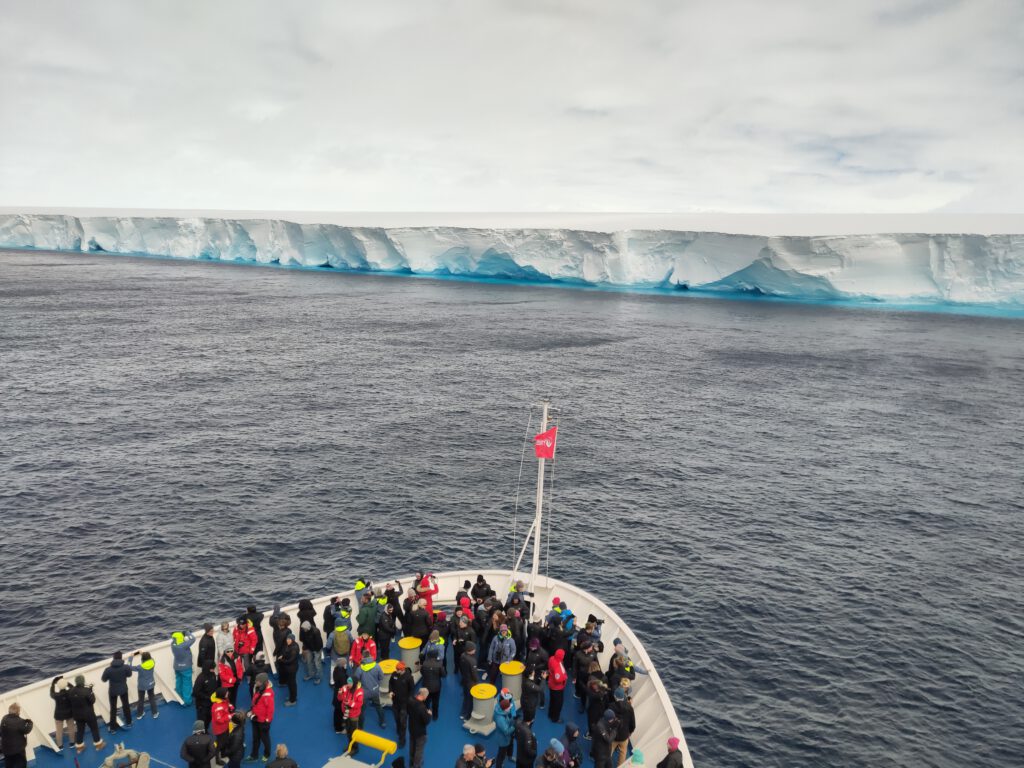
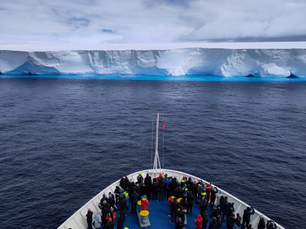
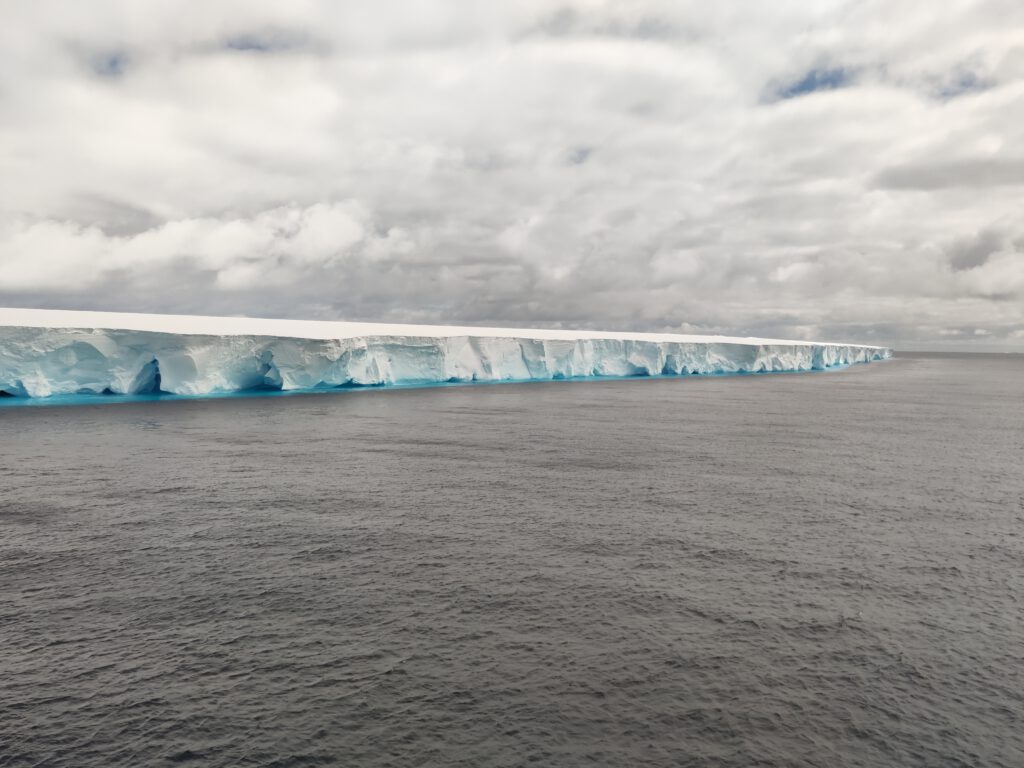
A23a is a tabular iceberg that broke off the Filchner-Ronne Ice Shelf in 1986. However, it was grounded (i.e. stuck on the sea bed) for several decades until it started moving in 2020. Since then, it has made its way past the Antarctic Peninsula and is heading for the South Atlantic Ocean.
The Filchner-Ronne Ice Shelf (aka Ronne-Filchner Ice Shelf) is one of 10 major Ice Shelves in Antarctica and borders the Weddell Sea. Generally, an ice shelf is „a large floating platform of ice that forms where a glacier or ice sheet flows down to a coastline and into the ocean surface“ (Wikipedia).
You may have heard about A23a in the news when scientists onboard the polar research vessel RRS Sir David Attenborough (operated by the British Antarctic Survey) were able to collect seawater samples around the iceberg when they passed A23a on their planned route towards the Weddell Sea.
A research station on an Iceberg!
The Antarctic research station Druzhnaya I was established on the Filchner Ice Shelf in 1975 by the Soviet Union. Eleven years later, in 1986, satellite images showed ice breakup near the station. Later that year the ice broke from the main ice shelf – and Druzhnaya I drifted to sea on top of the newly calved iceberg A23. The station was unmanned when this happened. Material from the station was airlifted to Druzhnaya III (Druzhnaya II was a temporary field camp operating in 1982), after the station had been discovered by a ship. Read more about it in this New York Times article from 1987.
Naming Antarctic icebergs
The U.S. National Ice Center (USNIC) has been tracking icebergs in the Southern Hemisphere since 1987. However, they are not tracking all icebergs; only those with a length of 10 nm or more on the longest axis. Since satellite imagery is constantly improving, the criteria has been expanded to include icebergs of 20 nm² or greater.
Icebergs that are monitored also get a name. The naming convention is derived from the Antarctic quadrant in which they originated. Hence, the name of an iceberg tells you which part of Antarctica it broke off from. These quadrants are divided counter-clockwise in the following manner:
- A = 0-90W: Bellinghausen Sea & Weddell Sea
- B = 90W-180 (Amundse Sea & Eastern Ross sea)
- C = 180-90E (Western Ross Sea and Wilkesland Sea)
- D = 90E-0 (Amery Sea & Eastern Weddell Sea)
The number in the name of the iceberg is assigned sequentially. For example, A23 is the 23rd iceberg tracked by the USNIC in Quadrant A of Antarctica. When already named icebergs calf or break up, a letter suffix is added in sequential order. Hence, A23a is the main part of A23 after it broke into two pieces.
You can find data on tracked icebergs at the USNIC website. They also post information about Icebergs breaking off, Sea Ice Extent in our Polar Regions and more on their NEWS website.
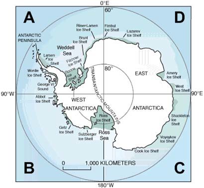
The Antarctic quadrant as the basis for naming the iceberg (taken from www.solcomhouse.com, in Iswari 2010).

DE: Während wir im November die Scotiasee von der subantarktischen Insel Südgeorgien zur Antarktischen Halbinsel überquerten, machten wir einen kleinen Abstecher, um etwas Spektakuläres zu sehen: A23a, den derzeit größten Eisberg der Welt. Mit einer Fläche von 3.900 km² wurde er nur im Mai 2021 vorübergehend von einem anderen Eisberg, A76, übertroffen. Bevor er auseinanderbrach, maß A76 beeindruckende 4.320 km².
A23a ist ein Tafeleisberg, der 1986 vom Filchner-Ronne-Schelfeis abbrach. Er lag jedoch mehrere Jahrzehnte lang auf dem Meeresgrund auf (d. h. festsitzend), bis er sich im Jahr 2020 entlang der Antarktischen Halbinsel zu bewegen begann und schließlich auf den Südatlantik zusteuerte.
Das Filchner-Ronne-Schelfeis (auch bekannt als Ronne-Filchner-Schelfeis) ist eines der zehn großen Schelfeise in der Antarktis und grenzt an das Weddellmeer. Im Allgemeinen ist ein Eisschelf „eine große Eisplatte, die auf dem Meer schwimmt und von Gletschern, Eisströmen oder Eiskappen gespeist wird und noch mit diesen verbunden ist“ (Wikipedia).
Möglicherweise hast du in den Nachrichten von A23a gehört, als Wissenschaftler an Bord des Polarforschungsschiffs RRS Sir David Attenborough (betrieben vom British Antarctic Survey) Meerwasserproben rund um den Eisberg sammeln konnten, als sie auf ihrer geplanten Route in Richtung Weddellmeer an A23a vorbeikamen.
Eine Forschungsstation auf einem Eisberg
Die Antarktis-Forschungsstation Druzhnaya I wurde 1975 von der Sowjetunion auf dem Filchner-Schelfeis gegründet. Elf Jahre später, im Jahr 1986, zeigten Satellitenbilder das Aufbrechen des Eises in der Nähe der Station. Später in diesem Jahr brach das Eis vom Haupteisschelf ab – und Druzhnaya I trieb auf dem frisch gekalbten Eisberg A23 ins Meer. Die Station war zu diesem Zeitpunkt unbemannt. Material von der Station wurde nach Druzhnaya III geflogen (Druzhnaya II war ein temporäres Feldlager, das 1982 in Betrieb war), nachdem die Station von einem Schiff entdeckt worden war. Ließ mehr darüber in diesem Artikel der New York Times aus dem Jahr 1987.
Manche Eisberge bekommen Namen
Das U.S. National Ice Center (USNIC) verfolgt seit 1987 Eisberge auf der Südhalbkugel. Allerdings werden nicht alle Eisberge verfolgt; nur solche mit einer Länge von 10 nautischen Meilen (nm) oder mehr auf der längsten Achse. Da sich die Satellitenbilder ständig verbessern, wurden die Kriterien auf Eisberge mit einer Größe von 20 nm² oder mehr ausgeweitet.
Eisberge, die überwacht werden, bekommen auch einen Namen. Die Namenskonvention leitet sich vom antarktischen Quadranten ab, in dem sie entstanden sind. Daher verrät der Name eines Eisbergs, von welchem Teil der Antarktis er abgebrochen ist. Diese Quadranten sind gegen den Uhrzeigersinn wie folgt unterteilt:
- A = 0-90W: Bellinghausensee und Weddellmeer
- B = 90W-180 (Amundsesee und Östliches Rossmeer)
- C = 180-90E (Westliches Rossmeer und Wilkeslandsee)
- D = 90E-0 (Amerikanisches Meer und östliches Weddellmeer)
Die Nummer im Namen des Eisbergs wird fortlaufend vergeben. A23 ist beispielsweise der 23. Eisberg, der vom USNIC im Quadranten A der Antarktis verfolgt wurde. Wenn bereits benannte Eisberge kalben oder zerfallen, wird in fortlaufender Reihenfolge ein Buchstabensuffix hinzugefügt. Daher ist A23a der Hauptteil von A23, nachdem es in zwei Teile zerbrach.